Beachy Head & Seven Sisters – The Thrill of Cliff Edge Theatre
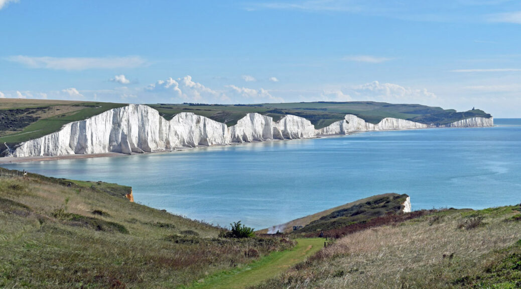
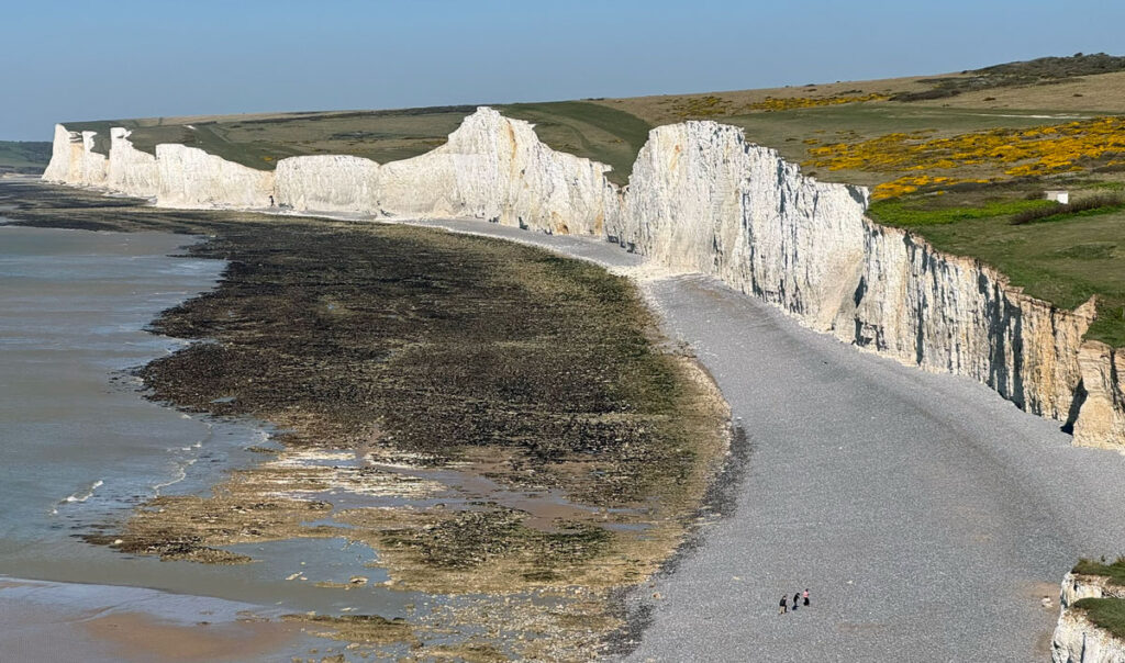
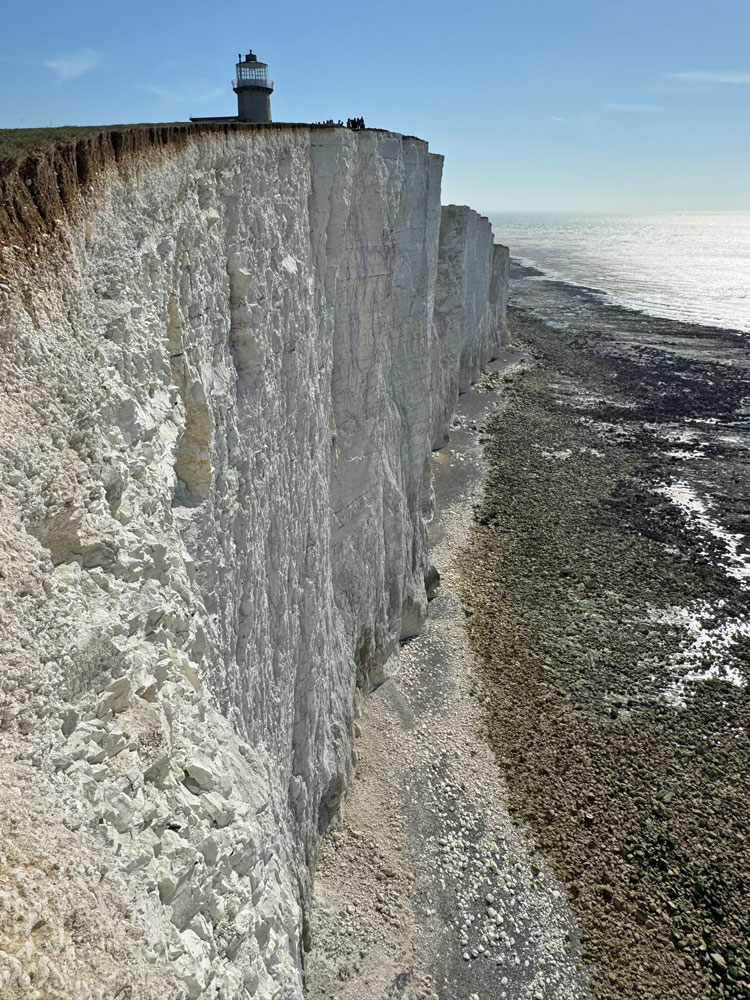
Beachy Head presents the highest exposed chalk cliffs in Britain, which together with the adjoining and equally precipitous Seven Sisters, comprises a landmark spectacle of extraordinarily raw grandeur. Danger is ever-present in the form of frequent rockfalls; the crumbling chalk crashing onto an uncompromising beach, itself blockaded by vast boulders and lashed by heavy seas.
Contrast this scene of devastation with the short-cropped grassy swathe atop the cliffs, offering a comfortable, albeit marginally precarious lookout post on the action, creating a unique clifftop walk that is one of Britain’s finest coastal outings.
The name derives from Beauchef, historic French for beautiful headland, thus it could simply be called Beachy, although the English translation added a tautological Head. Nonetheless, beautiful is perhaps not the most appropriate adjective for this fearsome stretch of coast that has witnessed many battles and caused countless shipwrecks.
The map can be zoomed in or out to change the scale
Beachy Head and the Seven Sisters form a continuous line of cliffs stretching between the town of Eastbourne and the estuary of Cuckmere Haven, the cliffs then rising again for a further couple of miles along Seaford Head. While our main considerations for Worthy status involve the actual walking, having the added interest of an upmarket resort and a wildlife reserve as bookends does no harm to the appeal. Ironically, it is the proximity of Eastbourne that has protected Beachy Head from unsavoury development, the town council having made an enlightened purchase of 4,000 acres around the headland a century ago. Eastbourne is a select resort in that no shops are permitted along the seafront and the council have extended this reputation for preservation to their management of Beachy Head, which remains mostly open access land.
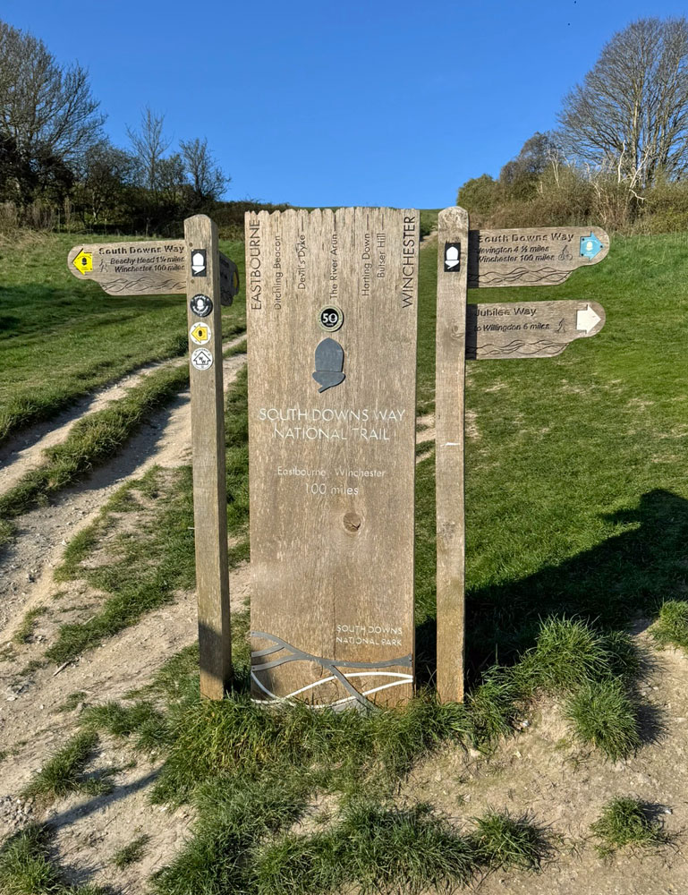
Beachy Head marks the eastern terminus of the South Downs National Park, which is traversed by the South Downs Way long distance footpath and it is a section of this path that forms the basis of our Worthy. Incidentally, it is also a terminus for the Weald Way (83 miles from Gravesend) and the Eastbourne Downs Jubilee Way, a local walk.
The cliffs can be followed in either direction as a linear outing, made eminently simple by making use of the frequent bus service. Or you may choose to retrace your steps as this is not a long walk. If you are a photographer then the ideal time of day is afternoon or especially a summer evening and, if you choose to include Seaford Head to extend the day, then this is best done west to east to enjoy the magnificent prospect ahead of the Seven Sisters (see photo at the top of the page).
Of course, there is the option of attempting a circular route by following the beach one way. Naturally this provides an astounding experience beneath threatening cliffs, although the going can be exceptionally arduous according to conditions. This is particularly the case under Beachy Head. You will find little sand (except closer to Eastbourne where are found the aptly named Falling Sands), lots of boulders, slippy seaweed and frequent rockfalls, which add to the time required to navigate the terrain. The section between the lighthouse and Birling Gap is the most hazardous. The going is less tough under Seven Sisters, although due to tidal restrictions managing the full beach walk in available time is unlikely. Fortunately, there is a half way access point at Birling Gap and the beach sections could then be undertaken on two separate occasions.
Over The Cliffs
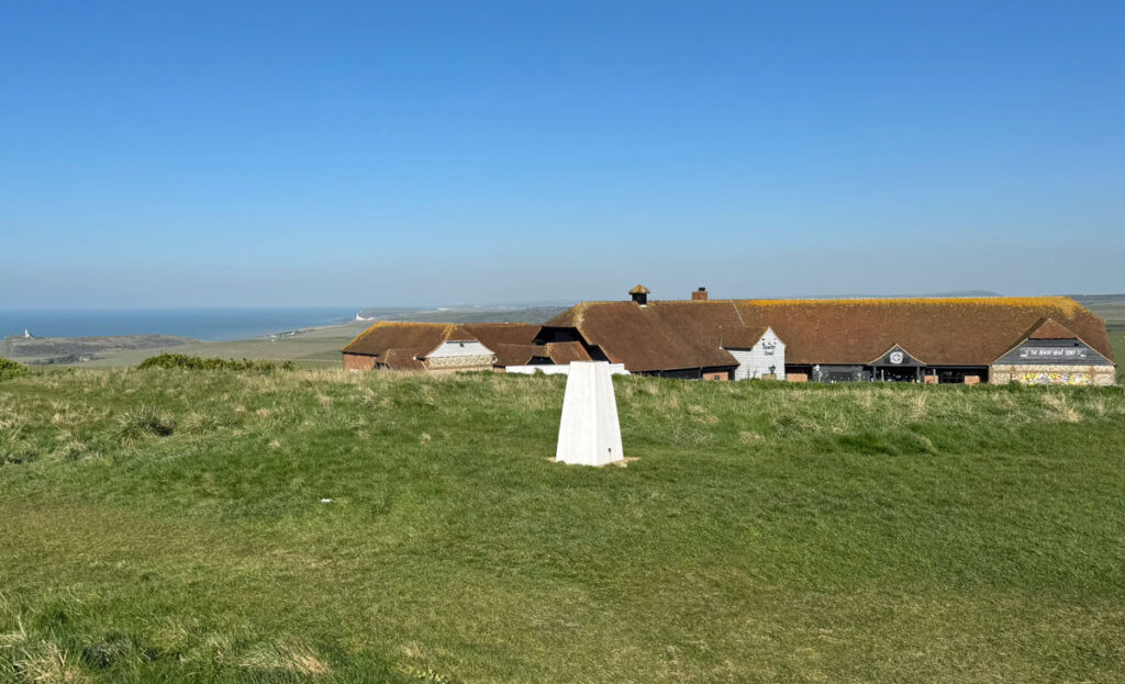
Our Worthies are certainly a diverse collection and strolling along the seafront at Eastbourne is a seemingly unlikely starting point for one. Nevertheless, go with it and embrace the unique stimulus. The town runs out at Holywell where there are a number of path options to begin the ascent, either attack it head on, followed by an easy stroll to the top of the cliffs, or take a more gentle track above the coast. The latter affords the option to explore the beach heading toward Beachy Head Lighthouse, accessed from steps at Cow Gap after around one mile. Staying on the coast, beyond here the cliffs begin to form, broken and populated by vegetation initially, forcing the path to climb steeply above. All paths converge close to the OS triangulation pillar close to the road at the summit of Beachy Head.
Tourist facilities abound with a large car park, pub and until recently a countryside centre exhibition chronicling the history of Beachy Head. The building opened in 1996 and closed in 2024 as a council cost saving decision to help fund accommodating the town’s homeless population. The former Beachy Head Hotel is now just a large pub. Originally built in 1880; it burnt down in 1966, was quickly rebuilt only to later burn down again in 1994.
Turning our attention back to the cliffs, there are also a number of structures recording the historic importance of Beachy Head.
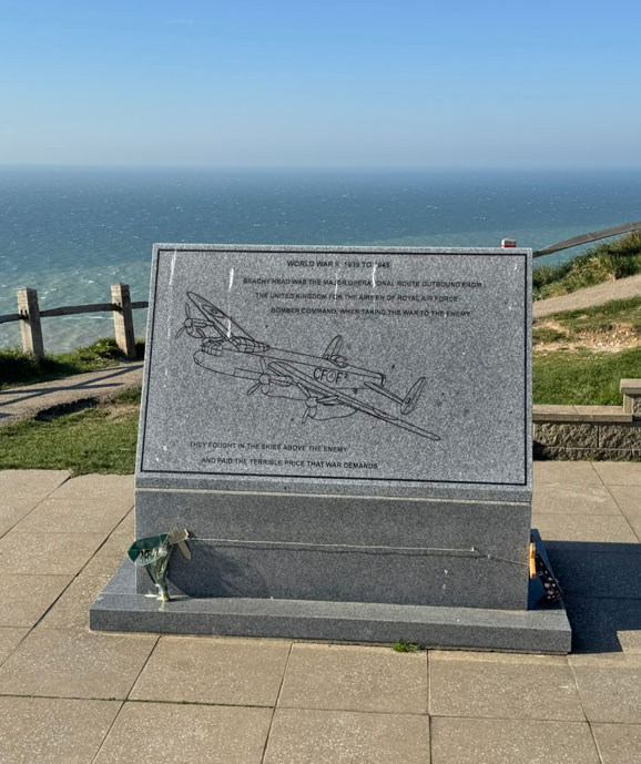
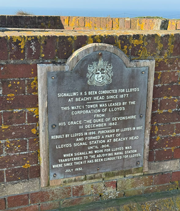
There is a remembrance memorial to RAF Bomber Command, which can also be reached by a circular ‘Peace Path’ suitable for wheelchairs, an inspirational facility allowing disabled access to some of the glorious views that we will experience on this walk. Nearby, a brick watchtower carries a plaque commemorating its use as a semaphore station for Lloyd’s Insurance to record the safe return of ships carrying valuable cargo.
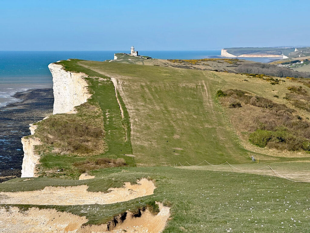
At this point, despite the spectacular cliff scenery, you may consider that because the highest point of the walk can be conveniently enjoyed with minimal effort by motorists, it renders this choice of Worthy questionable. This is a valid point, however, Beachy Head is merely the beginning and it is the cumulative experience of the walk that delivers the honoured status. Onwards, and as far as Birling Gap, the road does remain close in places, although it is below the level of the cliffs and not generally in our eyeline, so does not distract from the enjoyment.
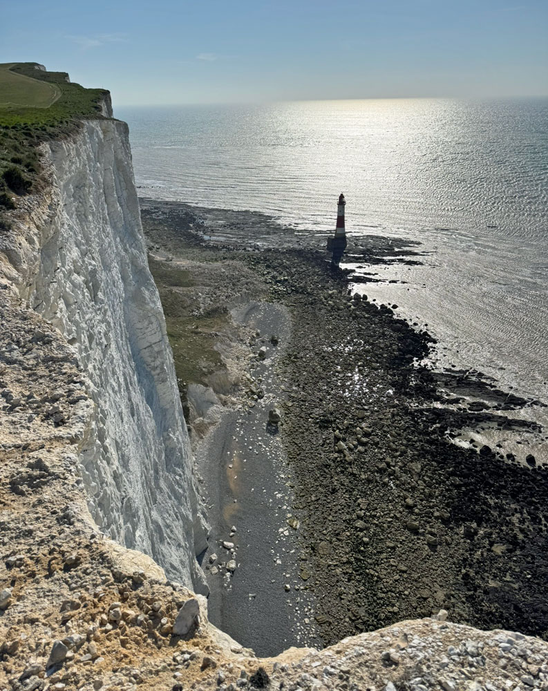
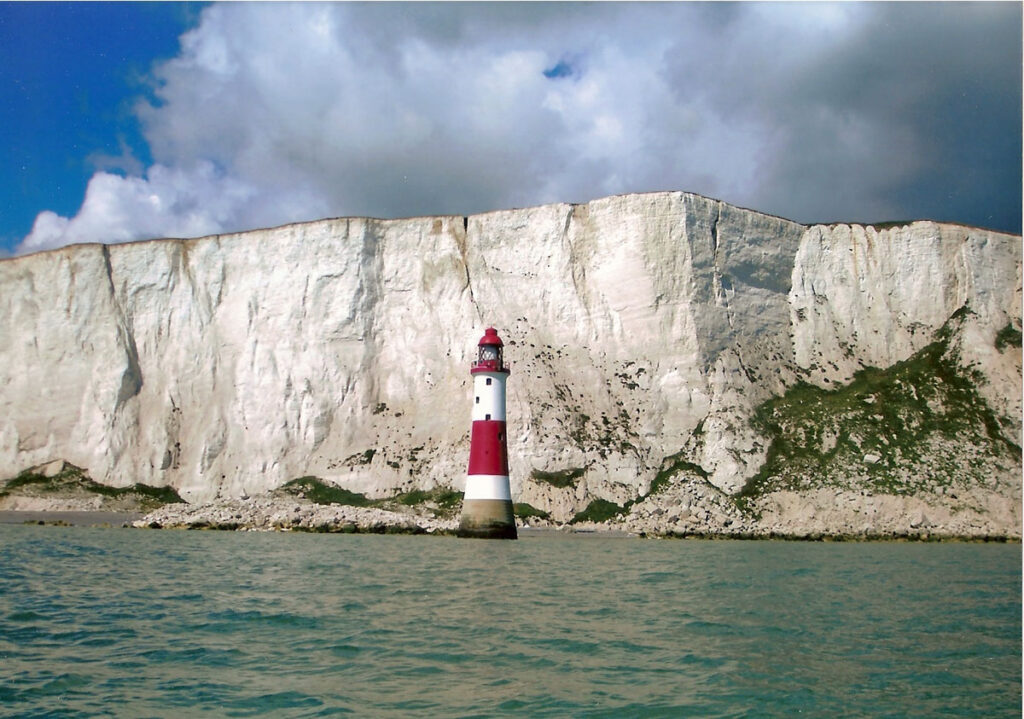
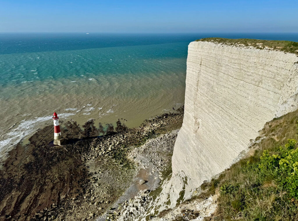
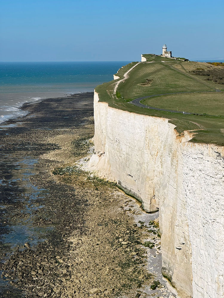
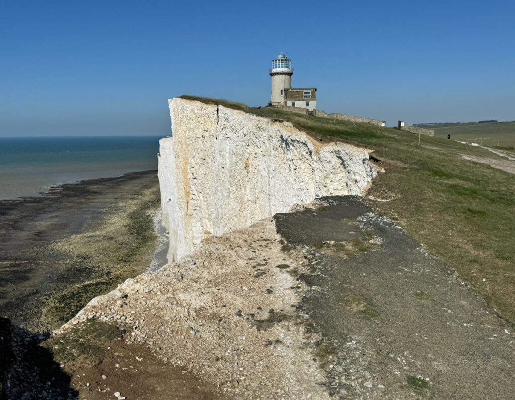
Already you will have been gazing at Beachy Head Lighthouse, dramatically situated on a chalk platform which provide the foundations. This platform is sub-tidal and often not visible, which is what makes these waters so treacherous for shipping and brought about the need for a lighthouse. In earlier centuries lights were lit in caves in the cliffs to warn shipping to keep away, until being made redundant by the stout Belle Tout Lighthouse, constructed in 1834. In theory it was a good idea for visibility to site the lighthouse on top of the cliffs, however, at such a height it was frequently obscured by low cloud. Added to this, the retreating coastline made the lighthouse increasingly precarious and the Beachy Head tower replaced it in 1920. This had to be built sufficiently distant from the cliff face to avoid the debris of frequent rockfalls.
Tragically, the cliffs in the vicinity of the lighthouse are renowned for suicides. Around twenty people a year end their lives here, this location seemingly chosen for its ease of access from the road. Far fewer jump from Seven Sisters which involves more of a contemplative walk in. Some chose to drive their cars off the cliffs, although banking created above the road prevent this now. Cars were also pushed over for sport. A team of chaplains patrol the area whose caring intervention has prevented many deaths.
Most of the cliff edge at Beachy Head is spanned by safety ropes, too low to exclude access to the edge but designed to keep walkers back from areas of unstable cliff.
Not surprisingly the dizzying heights above the lighthouse have attracted another form of jumper, the base jumper, hurling themselves off as an adrenaline trip. The sight of this has caused many false reports of suicide attempts and coastguards ask that base jumpers inform them of their activity in advance.
Another adventure sport that is rarely pursued here is rock climbing. Beachy Head, Seven Sisters and Seaford Head all have climbing routes, ascended by a varying mixture of rock and ice climbing techniques. The notorious writer and occultist Aleister Crowley was the early pioneer here in the 1890’s, followed many decades later by Mick Fowler in the 1970’s. Both had reputations as being at the forefront of unorthodox pioneering!
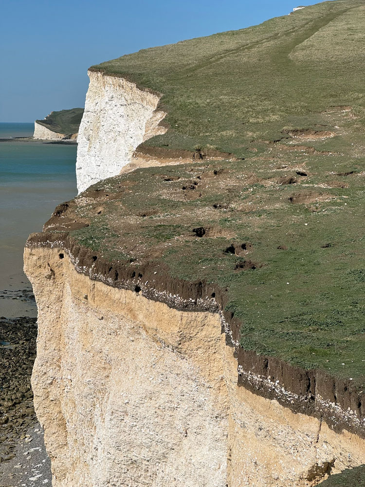
For us, the terrain begins to gently undulate as we head along the cliffs to Belle Tout, the lovely green path revealing surprisingly minimal evidence of erosion considering the large numbers who walk this way. Nonetheless, the erosion of the cliffs becomes ever more apparent, especially on the final approach to Belle Tout Lighthouse, where remains of the former cliff road has collapsed and plunged to the beach.
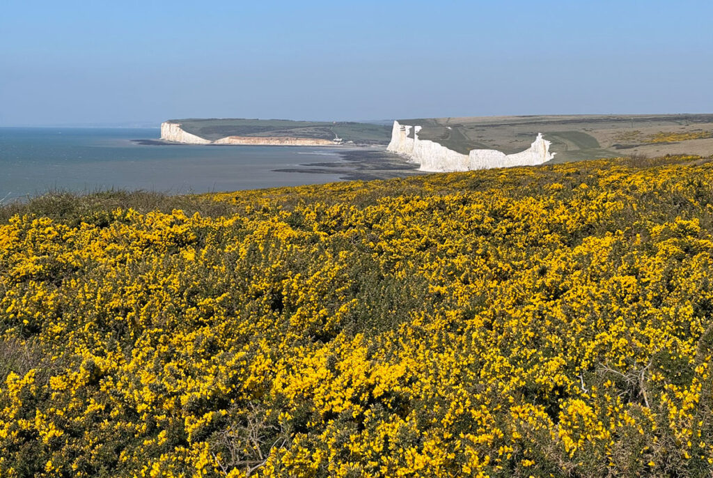
The scrubland from here as we descend to Birling Gap is grazed over winter by Exmoor ponies and displays spectacularly shimmering gorse during the spring. This, together with the chalk cliffs, estuary and downland landscape combine to offer a diverse habitat for wildlife, all protected, as the entire coast from Seaford to Beachy Head is a designated Site of Special Scientific Interest (SSSI) and also forms the Sussex Heritage Coast, the first to be designated in Britain.
Birling Gap is a tourist haunt, offering easy access to the shingle beach via a flight of steps. The area was purchased by the National Trust in 1982 under the Enterprise Neptune fundraising scheme, designed to protect important sections of coastline from development and overtourism. Birling Gap attracts around 350,000 visitors a year and on a busy day, you may wonder if the aims to control tourism have been achieved!
A hundred years ago there was no need for steps to the beach as it was possible to scramble up, although coastal erosion has steepened the slope and also claimed land formerly occupied by coastguard cottages. Rather than establishing coastal defences, the National Trust are following a policy of managed retreat, allowing the coast to erode naturally and simply moving or demolishing buildings as they become vulnerable.
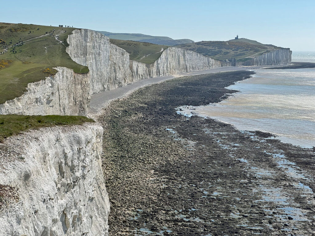
We continue with a gentle ascent, passing a row of houses that are safe for a while from the crumbling coast, onto the first of the Seven Sisters. The Sisters are separate headlands (known as Brows) divided by dry, hanging valleys (known as Bottoms) between the chalk ridges. Coastal erosion has left these valleys suspended above the beach. In truth there are eight sisters, although that does ruin the alliteration.
The first we encounter is Went Hill Brow, geologically the most recent of the sisters to be formed by coastal erosion. All the sisters present exceptionally bright, white cliff faces, being under constant attrition. This is not the case at Britain’s other famous white cliffs, Dover, which require defences to protect the port infrastructure and thus vegetation has been able to despoil them.
Once again, the grassy path on the gentle rollercoaster of headlands is a dream to traverse, even more satisfying than that over Beachy Head. Beachy may be higher but the Sisters feel more like proper (albeit small) hills.
In the next dip, Michel Dean (the only one not called a bottom), there is a WW1 memorial to two brothers of WA Robertson who were killed in action. The National Trust were given a bequest from the Robertson Memorial Fund, with which they purchased eight parcels of land. This part of the Seven Sisters was one such acquisition. The understanding was that each piece of land should carry a memorial to the brothers. The obelisk erected was formerly closer to Birling Gap but was moved to a safer location due to invading erosion, the cliffs here retreating on average by 70cm a year.
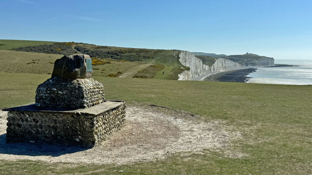
More hills and bottoms follow, a notable feature being many rabbit holes, so watch your footing! Half way along the cliffs another monument is encountered on Flagstaff Brow, a sarsen stone set on a flint plinth commemorating the purchase of the Crowlink Estate in 1926. Developers had bought the land with plans to build a town, something that had occurred previously to despoil the downs (nearby Peacehaven is an example), however, a fundraising group called the Sussex Downsmen (established after Peacehaven to protect the landscape) negotiated a resale. They had to pay almost twice the original buying price to save it. It was then bought by the National Trust.
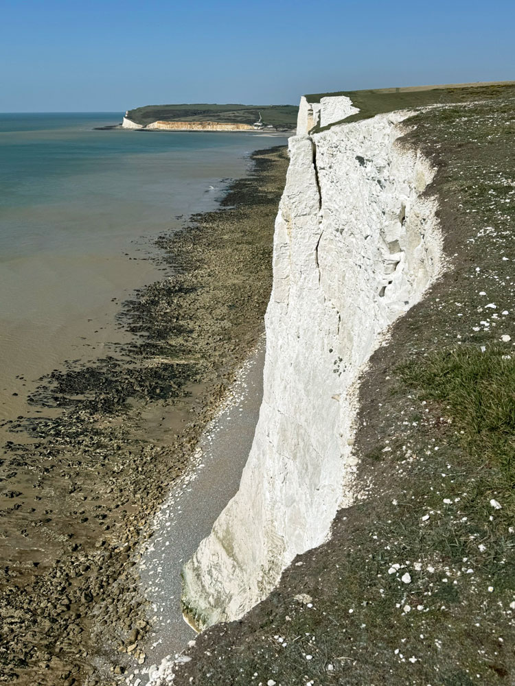
A major difference between Seven Sisters and Beachy Head is that the land rises inland from the cliffs at the Sisters, whereas at Beachy it falls. Therefore, as the cliffs erode they actually become higher as the crags nibble at the land behind. From Flagstaff Brow we descend into Gap Bottom, with a path running inland to Crowlink. This is the lowest point of the Sisters at around 20m above high water. A few hundred years ago the path extended further allowing access to the beach. From Gap Bottom we climb to the next hill, Brass Point, where, if you peer over the cliff edge the spoil of a huge rockfall in can be seen littering the beach. Although the pace of coastal erosion is averaged, it usually takes the form of isolated collapses.
The final hill is Haven Brow, overlooking Cuckmere Haven. You may choose to turn here and retrace your steps or continue down to the beach, whose combination of wetland, freshwater and marine habitat is a paradise for birds. It forms the hub of the Seven Sisters Country Park. In the eighteenth century Cuckmere beach could witness over two hundred smugglers arrive to receive illicit cargo from boats, something that occurred at many points where access to the beach was possible, such as Gap Bottom, Birling Gap and Cow Gap, all passed earlier on our walk.
From the estuary the South Downs Way climbs inland onto Exeat Hill, where the village of Exeat once thrived. This sizeable habitation was decimated by the plague and subsequently abandoned. Otherwise, follow a path beside the meandering course of the river to the Seven Sisters Country Park Visitor Centre. Management of the country park has recently been taken over from the council by the South Downs National Park Authority who have major plans to improve facilities. I am sure this will include retaining the bus stop, in case you are planning to return that way to Eastbourne!
Worth Rating: 68.5
Aesthetic – 21.5
Complexity – 9
Views – 16
Route Satisfaction – 14
Special Qualities – 8
While you are in the area…
The cliffs mark merely the seaward terminus of the South Downs, a mixed range of open land, farmland and woodland. Certainly, the open downs are of appeal to our interests and, within close proximity to the above clifftop stroll, are two areas well worth your attention.

A few miles north of Exeat is WINDOVER HILL, famed for its chalk cut figure of the Long Man, the largest cut figure of a human in Europe at 235ft tall. The date of creation is not known, although there are no records of it before the early 1700’s. It was recut in 1874 with some claims that it may have been doctored to preserve Victorian dignity! A fine, brief circuit can be enjoyed from Wilmington or the walk could be tagged on to the next range of hills, following the South Downs Way. This drops down to Alfriston before ascending onto the FIRLE ESCARPMENT, extending from the Cuckmere Valley for over six miles westwards to the Ouse Valley.
The escarpment is an extensive stretch of chalk downland noted for unusual and rare plants, with much of the summit ridge and the north facing slopes being a designated SSSI. The southern slopes are ‘improved’ agricultural land.
The climb from Alfriston begins abruptly then eases off to an easy stroll. The path is known as the Green Way, a most appropriate description. Without doubt the major attraction of this walk is the glorious downland views, with sea vistas adding a bonus to the south. However, there is much of historical interest with Bronze Age tumuli and barrows. These burial mounds are found at intervals along the full length of the ridge, which was clearly considered an important place to prehistoric man.
The first top is Bostal Hill, boasting views across to Windover Hill and is also where the first of many dew ponds will be found. All these artificial ponds have now dried up but were originally dug to provide watering holes for livestock. Some are several centuries old. They are a familiar sight on the South Downs and the National Park Authority are currently restoring nine ponds to improve wildlife habitat, including two on Seven Sisters.
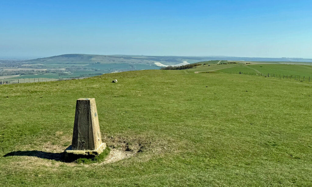
A road climbs to the ridge from the north, terminating at the Bo Beep car park, providing simple access to visitors (and paragliders) climbing both Bostal Hill and the next top, Firle Beacon, which is the highest at 712ft (217m) and furnished with an OS trig pillar. There are three round barrows on the summit, which was used a beacon for lighting warning fires during the Napoleonic Wars, hence the name of the hill. The last fire to be lit here was to celebrate Queen Victoria’s Golden Jubilee in 1887. A couple of hundred metres to the west is a long barrow, 112ft long and 70ft wide, which folklore names the Giant’s Grave.
Beyond is another car park on the ridge for Firle Beacon and Bedingham Hill, the next top, which is marked by radio masts. There is another OS trig pillar on the final and lowest top, Red Lion Hill. From here the ground dips pleasantly for the descent into the Ouse Valley. Alternatively, for seekers of a bus back to Wilmington, retrace your steps towards Bedingham Hill and descend north to the village of Firle.
