Gleouraich – A window into the wild
The two historic routes to the Isle Skye, through Glen Shiel and Glenfinnan demark a vast, remote mountain landscape penetrated by just two minor roads, both abruptly terminated by the fabled Rough Bounds of Knoydart. Amongst this wilderness are twenty-eight Munros with Sgurr na Ciche claiming first place in altitude and Gleouraich a close second. Whilst the former grips attention from every angle, Gleouraich is a benign presence above Loch Quoich, yet is of considerable interest to the discerning hillwalker.
Gleouraich is commonly climbed along with Spidean Mialach, part of a ten-mile range which, east of the two principal summits, broadens into a sprawling ridge gradually descending to the A87. Few people approach this way, or from the north, which affords the finest aspect, most making a circuit of the two tops from Loch Quoich (recently the Gaelic version, Loch Cuaich, has become more widely adopted).
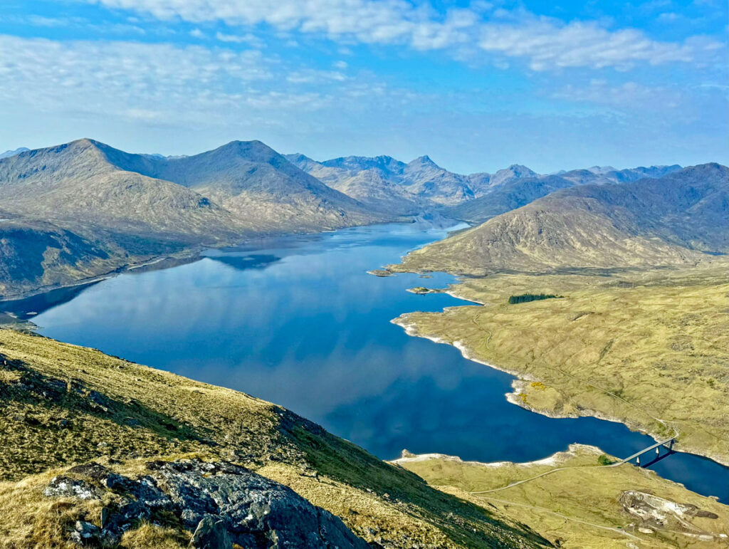
Loch Quoich was originally a natural loch some six miles in length, which more than doubled in size to become a reservoir contributing to the extensive Great Glen Hydroelectric Scheme. The reservoir opened in 1962 and is one hundred feet deeper than the previous water level. The area may appear ostensibly untamed, but evidence of man’s intervention is everywhere and likely to encroach further with the proposed Loch Fearna pumped storage scheme in the planning permission stage. Loch Fearna is a mountain loch suspended in a large bowl 2,000ft up Spidean Mialach. The bowl is perfect for expansion of the loch, which would work in tandem with Loch Quoich and be linked by underground pipes. The descent route described later comes this way, although if the bowl is fully flooded your feet may well get wet in the future!
Another cause for concern on Spidean Mialach are landslips, with a major occurrence in 2018 closing the road for six months. There are many parallels with the Rest & Be Thankful Pass running along southern flank of The Cobbler, the hillslopes failing at times of heavy rain – and of course Knoydart is renowned as one of the wettest places in Britain.
Parking for the ascent is above the loch at one of the few locations where water cannot be seen. This is due to a profusion of rhododendrons, something that may appear incongruous in such a generally open glen. However, these plantings are a legacy of the former Glenquoich Lodge, built for deer stalking on the estate. The whole area was once clan lands belonging to the MacDonnells of Glengarry, although during the impoverished years of the 1830’s the estate was divided and sold, Glenquoich being purchased by Edward Ellise who was captivated by the romantic vision of the Highlands. The lodge was built and later, when the estate was leased to the Bass Brewing family, it was enlarged for visits by Edward VII who stayed in 1904 and 1905. In 1955 the lodge was demolished and submerged deep under the reservoir.

The ascent path is widely claimed to be the finest stalker’s path in the Highlands, providing steady, easy angled access high onto the mountain. This feature is certainly a contributing factor to the enjoyment of climbing Gleouraich, allowing the simultaneous ability to walk and admire the ever-increasing panorama as height is gained. Initially the mountains of Knoydart provide the major focus, these being supplemented by the appearance of Ben Nevis and the ranges emerging to the north over the South Glen Shiel Ridge. It’s a spectacular assembly. Views ought to be ten out of ten, although some will find them tempered by the marching intrusion of electricity pylons and unsightly hydro access tracks.
Ambling up the path, there has also been ample time to mull over the pronunciation of Gleouraich and there are a number of claimants. Options begin with either glah, gloo, glower, glur or glaw and usually end with reek, often softened to sound more like reesh. Incidentally, Quoich is not ‘coy’ but more like ‘coo’.

We have the vigour of the estate during the sporting Victorian heyday to thank for this felicitous path. Often called Stalker’s Paths, these are in truth Pony Paths, created for ponies to carry the stalked deer down to the glen. Paths were surfaced with glacial till found locally or dug from a small quarry called a Borrow Pit. In general, pony paths were six feet wide and construction teams always included a tall boy who could be used to gauge the correct width!
Picture the scene on the momentous deer drives staged for the King and the illustrious members of his deer shooting party. To ensure maximum success, two hundred stalkers were recruited to drive deer into shooting range, paying particular attention to source the prized twelve pointed ‘Royals’ that were much coveted. Modern day stalking is fortunately more conservation conscious and designed to manage deer numbers, rather than capture trophy heads, with the older, weaker animals predominantly being the chosen targets.
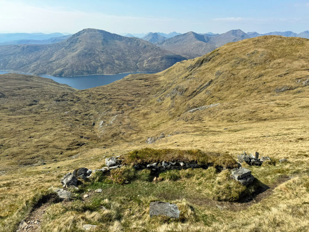
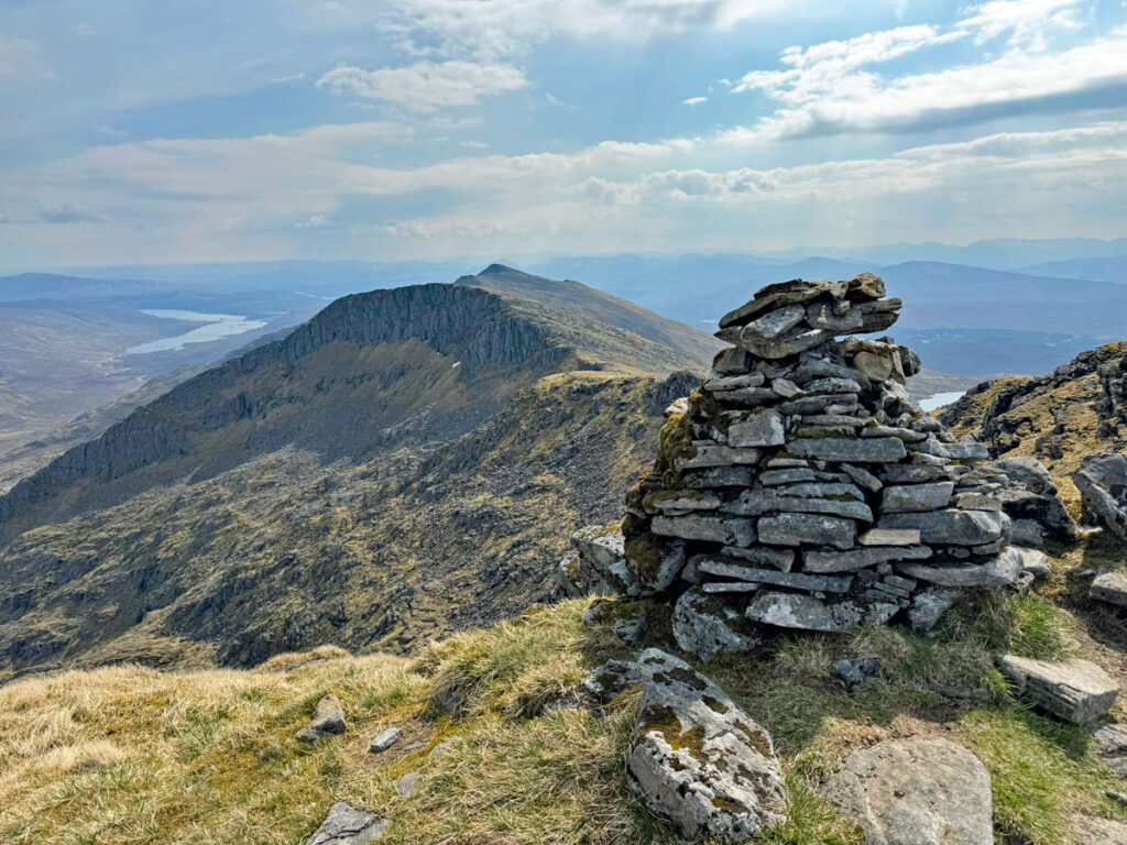
Our pony path terminates abruptly at 840m, 200m below the summit, at a low stone wall sheltering a small, flat, circular area. This is known as a Pony Stance, a place where the ponies waited for the quarry to be loaded, or perhaps one or more of the portly shooting gentry! The location is perfect for stalking, being above the open bowl of Coire Peitireach, ideal for confining the stalked deer.
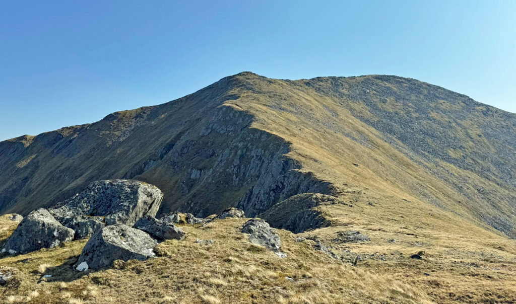
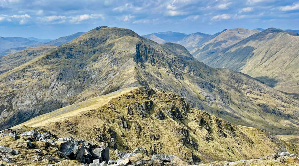
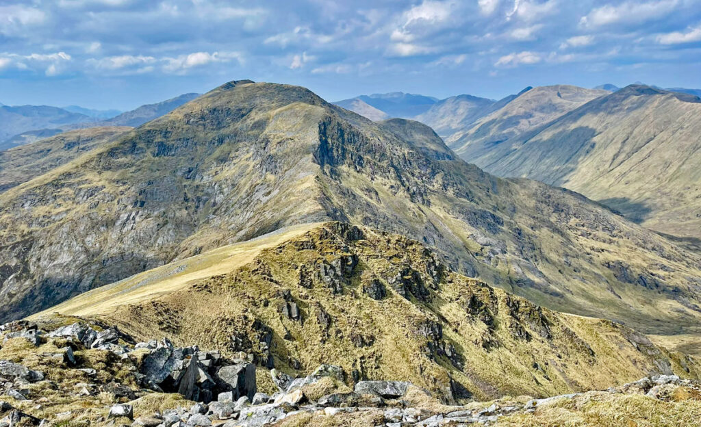
Following the carefully graded ascent, from the pony stance the path suddenly darts steeply up in a straight line, as though becoming excitable after being let off the leash. It soon settles down from rash attack and the summit of Gleouraich at 3396ft (1035m) is attained without difficulty. It’s a grand place to be and if this was the sole target for the day, with a return made by the pony path, there would be few easier high Munros to bag. However, the day is still young and there is an inviting ridge beckoning to the east, above the rocky northern corries culminating at Spidean Mialach.
It’s straightforward going to Gleouraich’s subsidiary eastern summit of Creag Coire na Fiar Bealach, your gaze frequently directed north across to the South Glen Shiel Ridge. In fact, the prime views of our two mountains are from that ridge, revealing the rugged northern aspect at its finest.

From Gleouraich, the ridge to Spidean Mialach appears to be gently undulating, although if you have done your research the sudden drop between the peaks of almost 900ft (270m) will come with less of a gulp. Nevertheless, fear not as another wonderful stalker’s path gracefully descends to Fiar Bealach. The Glenquoich Estate constructed 135 miles of stalker’s paths in these hills, bless them.
The subsequent climb to Spidean Mialach is equally undaunting and achieved with surprising ease. When taking the odd breather, look back to the zig-zagging stalker’s path on Gleouraich and admire the genius of the gamekeepers.
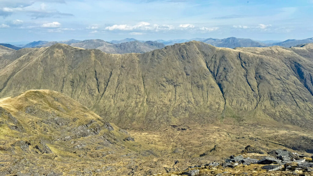
The north face of Spidean Mialach is even more rugged than Gleouraich, being sculpted into a complex of six high corries. The ridges between, when climbed from Glen Loyne, do provide exciting ascent routes (of no major difficulty) with a much more remote atmosphere, although the starting point is a long way from anywhere. The north ridge of Gleouraich can also be ascended by a stalker’s path from Alltbeithe.
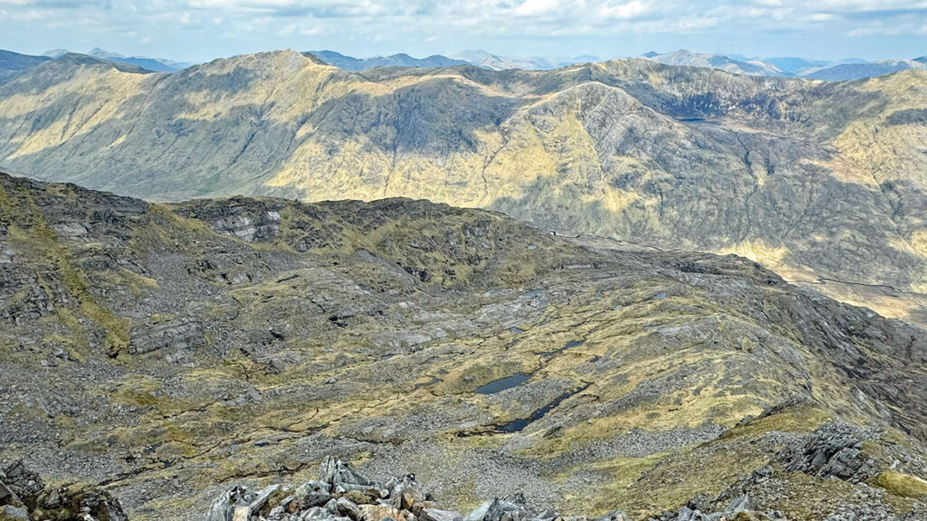
As for the usual descent, this commences by heading towards Loch Fearna, the path soon slanting right. It offers a promising start, then becomes rather boggy and less easy to locate which, after the exemplary paths experienced up until now, may well bring a slight sense of disappointment. Nonetheless, compared to much of the Highlands this descent is a doddle! Once the river is crossed a more obvious and drier stalker’s path returns to the road at Loch Quoich.
Many guidebooks (including Walk Highlands) suggest taking this circuit by climbing Spidean Mialach first. This has the benefit of getting the less pleasurable part out of the way at the beginning of the day, although personally I prefer to descend this way as it’s pretty quick and direct, thus spending less time on the less pleasurable part. Ascending via the Gleouraich path means it can be savoured for longer… and that is a major delight of this splendid outing.
Worthy Rating: 77
Aesthetic – 21
Complexity – 14
Views – 19
Route Satisfaction – 16
Special Qualities – 7