
Snowdon – The Monarch of Eryri
Snowdon is majestic in its glacially sculpted profile, exuding undisputed dominance as the fundamental nucleus of the national park that bears its name. The mountain well deserves its plaudits and is all things to all people, a multifaceted giant, friendly in benign conditions to all abilities, yet with a ferocious reserve for those who stray from sound judgement.
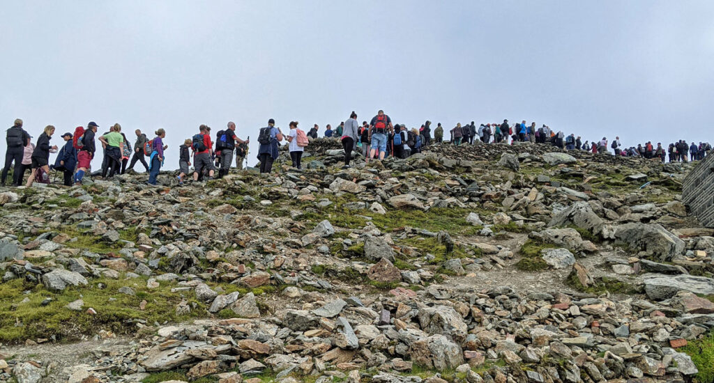
Snowdon is the most-climbed mountain in Britain with over 600,000 walkers and a further 140,000 attaining the summit by train every year. The number of walkers has almost doubled in the last decade, primarily due to the influence of social media rather than a rapid expansion of the hillwalking community. Many of these people will only ever climb Snowdon once, as a bucket list challenge, although in fact this is nothing new, because the attraction of Wales’ highest peak has been irresistible for over two centuries, with the first facilities for tourists having been installed in the early 1800’s. In every way Snowdon was the pioneer of mountain tourism in Britain.

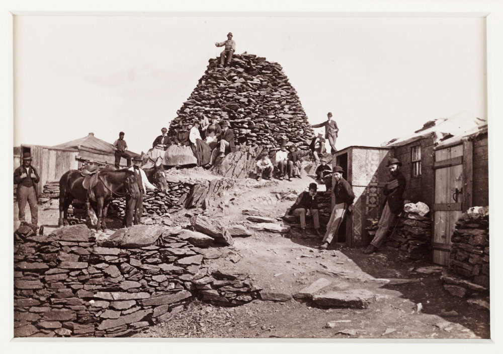
We may think climbing hills to see the sunrise is also a social media creation but people were climbing Snowdon for this very reason two hundred years ago. In the 1840’s two wooden huts were constructed on the summit to sell refreshments, the huts soon being extended to offer accommodation. Guides made a full time living during the summer escorting visitors to the top, some of them on ponies stabled at Llanberis and Beddgelert hotels. These became redundant in 1896 when the mountain railway opened, adopting technology from the Alps and using Swiss built steam engines, two of which still operate today (admittedly now running on clean burning eco-coal).

By the 1970’s pressure of visitor numbers was causing grave concerns. At that time there were around 120,000 walkers (plus 90,000 on the train), nothing like today’s numbers but paths were badly eroded and the summit was an unsightly mess. A report was commissioned which concluded that Snowdon performed a useful function as a honeypot, reducing pressure on other parts of Snowdonia “but, as such, it is recognised to be seriously needing a positive management policy to keep pace with erosion by tourists.” The veracity of the statement claiming Snowdon drew people away from other areas was then and remains debatable, as most of these people are not regular walkers and wouldn’t consider climbing any of the other mountains anyway. However, a positive outcome was considerable funding enabling footpath improvements to be undertaken, something that continues to this day.
The report also called for a new station building, although this did not materialize until 2009. With the recent explosion in footfall even that is woefully inadequate to cope with the influx on summer days when queues to reach the trig pillar are frequently over thirty minutes in duration.
The map can be zoomed in or out to change the scale
A Precis of Paths
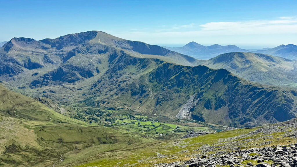
Most of the summiteers initially congregate before their final ascent at Bwlch Glas, where the Llanberis Path and the PYG/Miner’s Tracks converge. Eighty percent of Snowdon’s walkers use these three paths with the Llanberis being the outright busiest, carrying around a quarter of a million pairs of boots each year. Does it therefore follow that the Llanberis Path is the best route? Well, that depends on your criteria. For most who go this way they do so because most go this way…
There are six recognised major routes to the summit, although there are many more and several partial alternatives to the big six.
Let us begin with the Llanberis Path, carrying 42% of Snowdon hopefuls. Most of those ascending are not customarily hillwalkers, although those that are do not generally rate this route highly. The views across to Moel Eilio are very fine, although the best feature is the sight of Clogwyn D’ur Arddu, the aptly named black cliff of the black height, whose fearsome north facing aspect receives few rays of sunlight. With admiration and affection climbers simply call it ‘Cloggy’. To me as a young aspirant climber in the 1970’s Cloggy was the hallowed crucible of adventure. Nevertheless, on a recent visit, I observed those tramping up the Llanberis Path and few appeared to even notice Cloggy’s brooding presence, nor did everyone adhere to the pitched path recently created to resolve erosion, preferring instead to tread upon the reclaimed softer grass at either side. This is an inherent issue with footpath restoration, as walking on laid stone is hard on the feet especially over long stretches.

The Llanberis Path is the way tourists traditionally ascended the mountain and a café called Halfway House was erected in 1873 to serve tea and lemonade during the season, a function it still fulfils today. Another attraction of the path is the proximity to the mountain railway, lending a holiday atmosphere to the outing. As such the Llanberis Path perhaps feels less like mountaineering than any other ascent. However, if the alternative, parallel route on the ridge above to Llechog is taken then the flavour of mountaineering is fully restored. I call this a route rather than a path because in places it is trackless, quite remarkable really for the country’s busiest mountain. It’s rough going in places too, something amply compensated by the bird’s eye views of the Llanberis Pass. The route joins the Llanberis Path at Clogwyn Station, just above Llechog. Note there are two Llechogs on Snowdon, the other being on the Rhyd Ddu Path. There is also a Tryfan, below the Llanberis Llechog, from where you can just see the more famous Tryfan.

Of the major six, the other recognised easier ascent is the Snowdon Ranger Path. For mountaineers it is as similarly unexciting as the Llanberis Path although considerably quieter. The name comes from John Morton an enterprising mountain guide in the mid 1800’s who adopted an ancient local title and called himself the Snowdon Ranger (other guides followed suit), also establishing an inn, which is now a youth hostel. This path up Snowdon is probably the earliest in regular use, primarily due to accessibility from Caernarvon and its use to transport copper from the Snowdon mines. From the path, the views are mostly of the fine prospect to the west taking in Mynydd Mawr, the Nantlle Ridge and Moel Hebog. Things open out in the higher stages when the path traverses above the top of Clogwyn D’ur Arddu, although to fully appreciate the precipice a bit of off-piste is required. Beyond, the path crosses the railway to Bwlch Glas and joins the crowds. However, up until this point the Snowdon Ranger Path accounts for only a little over three percent of total ascents.

Almost as quiet is the other major path on the west side, the Rhyd Ddu, although ‘quiet’ is relative as there are still over 20,000 people using these paths each year. Historically, Rhyd Ddu received a boost from a shrewd marketing ploy when the railway halt there was renamed Snowdon Station, something that directly influenced the decision to build a mountain railway from Llanberis to reclaim tourist attention.
The first part is a gentle approach, the central section is steeper and on a scrappy path relieved only by the splendid views again to the Nantlle Ridge, but it is the final section that makes this route worthwhile as the crest of Llechog’s tumbling crags is reached. This is followed by a zig-zag ascent to Bwlch Main, from where a delightfully airy, nonetheless straightforward narrow ridge provides the flourishing finale to the summit.
The majority of those on the Rhyd Ddu Path will ascend and descend the same way, however, the alternative of the South Ridge adds immense interest. The South Ridge is easily attained by continuing on beyond the initial section of the Rhyd Ddu, following an old quarry track, which heads to Bwlch Cwm Lan. In terms of altitude, we are only half way to the summit so a stiff climb remains, however, it offers more continuous interest than the Rhyd Ddu and this takes your mind off the hard work. The ridge is not especially narrow and there is just one short section requiring easy (and not exposed) scrambling. This leads to Bwlch Main where the Rhyd Ddu is joined for its finest, topmost section.
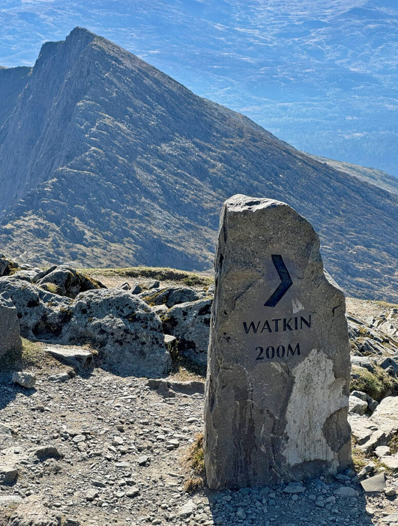
The South Ridge can also be used as an alternative to our next main route, the Watkin Path. Despite being generally regarded as the toughest approach this is a popular ascent. It begins at Pont Bethania in Nant Gwynant, the lowest point above sea level of any of the paths. Those from Pen y Pass involve a thousand feet of ascent less than the Watkin!
Created by and named after Sir Edward Watkin, railway magnate and politician who purchased part of Snowdon and enjoyed his retirement there, the path was purpose built to provide safe access to the summit from the east. It became Britain’s first designated mountain path and was officially opened by Prime Minister William Gladstone in 1892 to a crowd of two thousand people, who gathered in Cwm Lan in spite of typically damp weather.
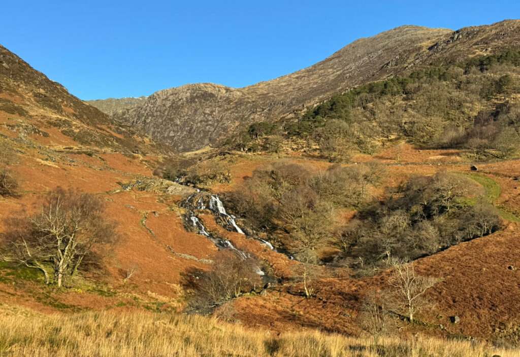
The path begins pleasantly through woods before joining much reconstructed quarry tracks passing attractive waterfalls into Cwm Lan. From here the nature changes as things steepen up, reminding us that this ascent involves the most height gain of any path. A stony ladder mounts the western flank of Y Lliwedd attains Bwlch Ciliau to be greeted by jaw dropping views over to Crib Goch. Take a breather, as the final climb to Snowdon summit is a skitter up and across loose scree, although the path is currently being restored so future visits should become more tolerable.
Finally, the two major paths from Pen y Pass are interchangeable to some extent, the PYG Track and the Miner’s Track. With a lofty starting point these are sought after ascents, the limitation being parking availability, nonetheless they each account for twenty percent of all walkers on Snowdon. Both paths are well engineered but rocky in places.

The PYG (sometimes Pig) Track is a curious name with no definitive derivation, possibly linked to the historic climber’s inn, Pen y Gwryd or (probably more likely) to Bwlch Y Moch (Pass of the Pigs), which is crossed on the walk. The first section to the Bwlch y Moch is a healthy climb, followed by easier gradients until the final steep pull to Bwlch Glas. Conversely the Miner’s Track, more obviously named for the copper mines it served, begins in a very leisurely fashion taking waterside strolls alongside three glacial lakes and crossing a causeway over the largest, Llyn Llydaw, whose waters are fed by a pipeline down to Cwm Dyli hydroelectric power station, Britain’s oldest, in continuous operation since 1906. Above is Glaslyn, the blue lake, contaminated by copper so without life. Both lakes are nevertheless teeming with folklore. Above Glaslyn your thoughts will rapidly turn to the task ahead with 1500ft to climb within a single mile to the summit. Spare a thought for the ponies that formerly dragged sledges loaded with copper ore this way for transportation to Caernarvon before the Llanberis Pass road opened in 1832.
The Summit

Snowdon means Snow Hill and has been known as such for over a thousand years. Snow is of course a common occurrence in the winter and during a blizzard or on a day deluged by rainfall, it is the only time you are ever likely to be alone on the summit. It doesn’t help that the trig pillar is perched aloft on a small platform reached by stone spiral staircases, however, for many this will be the only time they ever stand on this point, so enduring the queue is necessary, or even adds appeal for some, the popularity demonstrating that what they have achieved is significant.
The trig pillar was one of the original ‘Primaries’ for the Ordnance Survey, however, it was soon demoted due to interference caused by the summit buildings in favour of nearby Garnedd Ugain. The pillar was rebuilt in 2001 and a brass toposcope added indicating one hundred places (mostly mountains) visible on a clear day, some over one hundred miles distant. It’s a fine place to be with a feeling of being lord of all you survey, even though your subjects may pay you no heed.
The mountain railway terminus is only just below the pillar, with the summit visitor centre adjacent, which does exacerbate the overcrowding in the immediate area. It has long been so, in fact there were formerly far more buildings up there. In 1935 all was swept away (some of it simply thrown off the top) to be replaced by a new summit building designed by the local, distinguished architect Clough Williams Ellis, although this structure was far removed from the fanciful Italianate village he famously created at nearby Portmeirion. The structure was deliberately designed to be functional not ostentatious and cost restraints enforced the use of concrete, although large windows softened the impact of austerity. Sadly, the glass was frequently smashed by gales and window sizes progressively reduced, further squeezing any charm exuded by the grim façade. Later the then Prince Charles famously called it ‘The highest slum in Wales’.
The present edifice is known as Hafod Eryri, which translates as Snowdonia’s upland summer residence, a name chosen from many entered into a BBC competition. Eryri is the romantic Welsh name for Snowdonia, evoking images of imperious white-tailed eagles that once soared amidst these heights. Yr Wyddfa is the Welsh name for Snowdon itself and derives from the burial place of a legendary giant. The National Park Authority in recent years have decided to refer to each only by their Welsh names in order to highlight and preserve Welsh heritage.

Routes for the Connoisseur
In addition to the six paths expounded by most Snowdon propaganda there are many other routes of ascent. The Llechog Ridge and the South Ridge have already been suggested above, but there are several more. Some are walker’s routes and others involve varying degrees of scrambling.

Between the Llanberis and Snowdon Ranger paths is a high-level ridge from Moel Eilio running like a big dipper to the summit of Snowdon and including four tops along the way. It is variously known as the northwest ridge or the rollercoaster!
The Moel Eilio hills are an excellent short day in themselves so a shortened version for Snowdon is to follow Maesgwm (known as Telegraph Valley due to a previous line of such poles) to the pass (Bwlch Maesgwm), then cut across to join the Snowdon Ranger. This route offers another fine alternative to the Llanberis Path.
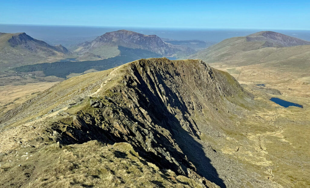
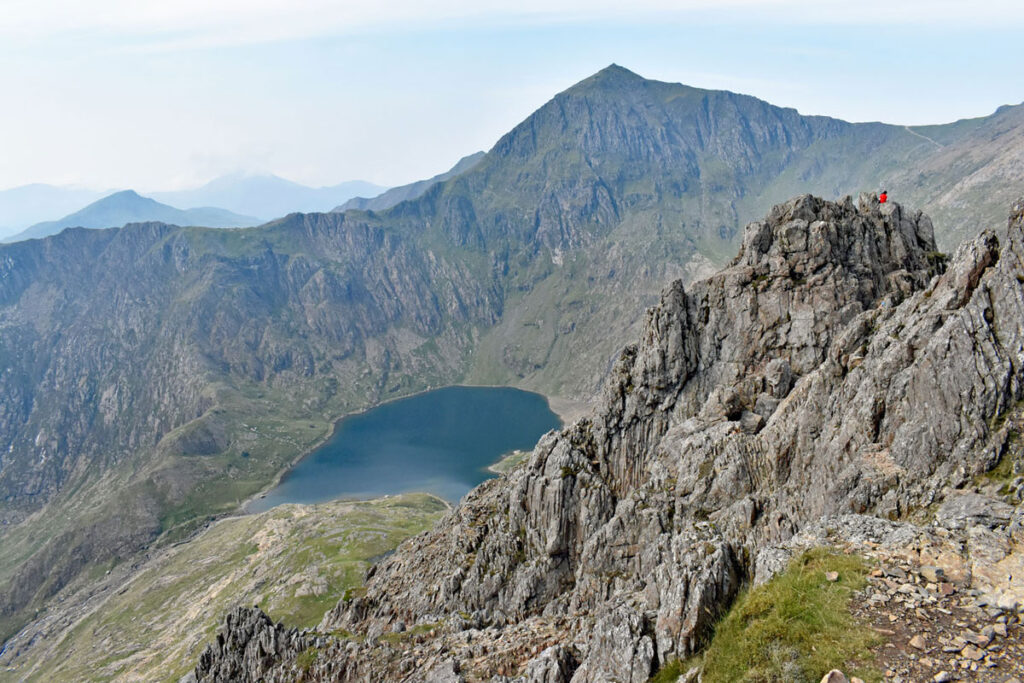
Y Lliwedd is an eastern spur of Snowdon and a magnificent mountain in its own right, being an integral part of the iconic view framed from the Capel Curig road.
The normal approach is from Pen y Pass, although an off the beaten track alternative is to start via the Watkin then cross the river by the waterfalls to head for old copper mines below Gallt y Wenalt. From the mines to the ridge is mostly pathless. The upper ridge itself is steep and inspiring but has no difficulties. The summit of Y Lliwedd at 2946ft 898m) is wonderfully pointy, although would have no chance accommodating the 600,000 Snowdon walkers if they decided to jump ship!
Taking Y Lliwedd, Snowdon and the South Ridge as a circuit is known as the Southern Horseshoe. Yr Aran can be tagged on for the complete ‘alternative’ experience.
From Pen y Pass, Y Lliwedd is customarily included as the latter top on the better-known Snowdon Horseshoe, which begins with the ascent of Crib Goch, the domain of scramblers.
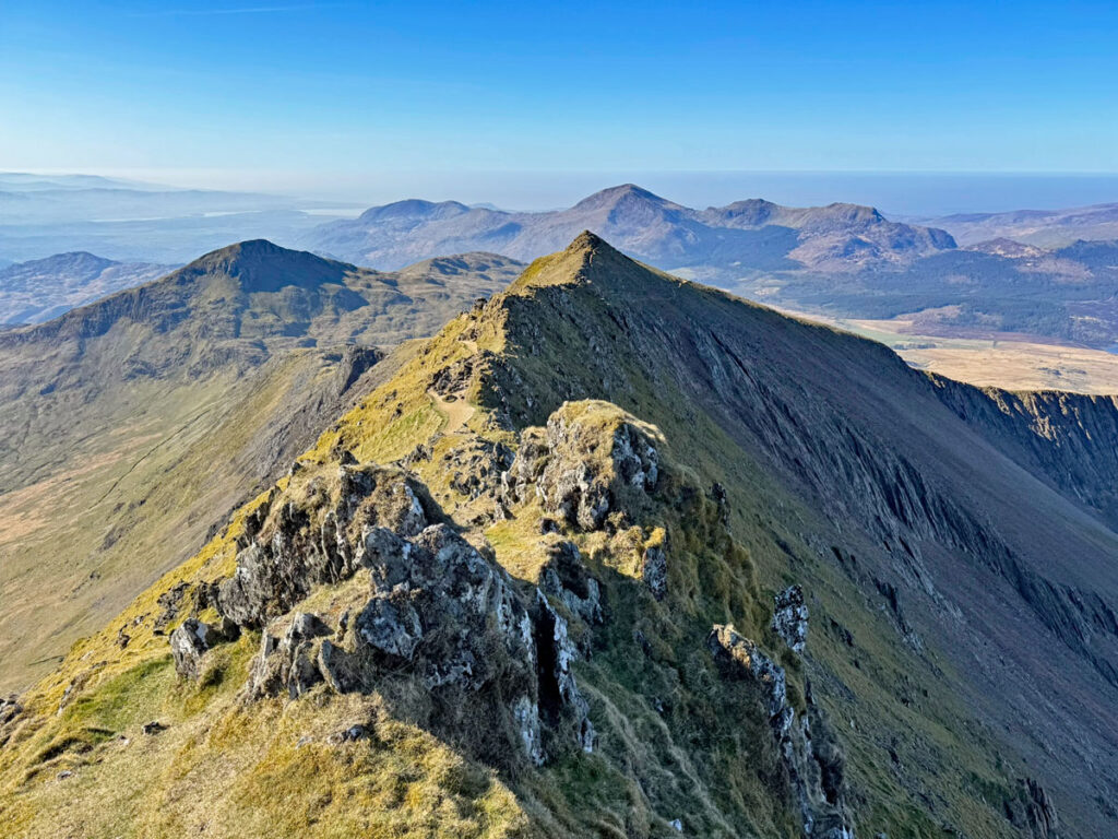
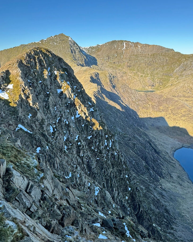
And finally to those scrambling routes of which Crib Goch’s east ridge is the people’s champion, ascended by over 30,000 people each year, with queues often forming on the celebrated narrow arete. Crib Goch is often thought of merely as the arete, although it is a separate mountain connected to Garnedd Ugain by the arete and the scramble of Crib y Ddsgyl. On the climb to its summit from Bwlch y Moch there are numerous possibilities, some quite difficult, so do be careful to check your route finding and not blindly follow others. There is one ‘bad step’ to look out for which can be avoided to the left. On the ridge most of the difficulties can also be bypassed, allowing the airy grandeur to be savoured without unnecessary concern for safety. Nonetheless, this is no place for the inexperienced.
The north ridge of Crib Goch is another fine scramble, arriving at the summit of Crib Goch where the spiky arete beckons ahead. To reach it a tenuous route called the Fox’s Path turns right just before the usual means of approach from Bwlch y Moch turns into a scramble. It cuts diagonally across to the foot of the north ridge, which provides exposed grade 1 scrambling. This ridge can also be reached by a quiet, rather more tiring approach from lower down the Llanberis Pass at Blaen y Nant, climbing Cwm Glas to Lyn Glas (not Glaslyn!). In this case most often the north ridge would be used as a descent, the upward route being the Clogwyn y Person Arete, directly above Lyn Glas. This, however, is a grade 3 scramble and many people prefer to rope up on it for safety.
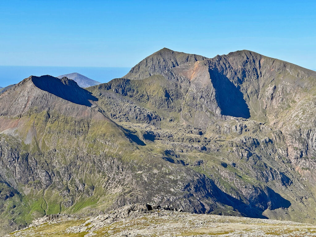
All these routes culminate at the summit of Garnedd Ugain. This is the second highest summit in Snowdonia at 3594ft (1065m) and one of the fifteen famed Welsh Three Thousanders, although effectively it is simply a north top of Snowdon.
Finally, there is Y Gribin, not the one on Glyder Fach, but a grade 1 scrambling ridge rising directly above Glaslyn on the Miner’s Track. OS maps mark it as Cribau. It is little frequented and the surroundings are stunning, the route climbing between the imposing north faces of Snowdon and Y Lliwedd, immersing the ascendant in rocky nobility.
A multitude of paths have been recorded above, but there is one that is rarely undertaken, yet is the most challenging of all – The Snowdon Girdle. This links the six cwms that surround the summit, without ever reaching the top and is the ultimate way to become intimately acquainted with the mountain. For an entertaining account of this tough expedition follow this link: https://www.iainshillwanderings.co.uk/post/the-snowdon-girdle

Synopsis
In preparation for this feature I reclimbed Snowdon several times, yet only once did I actually attain the very summit. Partly this was due to avoiding the melee but also because my explorations revealed so many routes that felt complete without needing to stand on the topmost point. Snowdon is that sort of mountain, not a single summit but an extensive, complex and self-contained massif.
Spiralling pressure of footfall is not sustainable, especially for the Llanberis Mountain Rescue Team, by far the busiest in Britain handling over three hundred rescues a year. It is worth noting that Crib Goch is not their major call out, it is the most popular paths where ankles are frequently twisted (the main cause of call outs). The demographic requiring rescue is increasingly younger people, coming as no surprise because there are more of them – these are the people that have generated the increase in visitors. Everyone has an unequivocal right to climb Snowdon but its popularity induces negligence, except perhaps for dedicated hillwalkers who undertake a subliminal risk assessment beforehand.
Nonetheless, despite the deluge of visitors, you can climb Snowdon without barely seeing anyone, even on a typical summer Saturday that might see 5,000 people on the mountain. Choose your route according to the day and for the mountain walker Snowdon continues to rank with the finest.
Further reading:
There is an excellent website compiled by volunteer wardens, which contains an enormous range of information:
Snowdon (Yr Wyddfa) Info
Worty Rating: 86
Aesthetic – 27
Complexity – 17
Views – 19
Route Satisfaction – 14
Special Qualities – 9
2 thoughts on “Snowdon – The Monarch of Eryri”
A fascinating piece of writing, and reading it, not only took me back to my memories of those routes, but I learnt a lot I did not know about the history and the popularity statistics, and also that there are 2 Llechogs and 2 Tryfans! I also didn’t realise you can traverse to the North ridge of Crib Goch from the route up the east ridge.
Thank you so much Adrian! I really enjoyed revisiting Snowdon for the several times it required, and delving into its history.