Kinder Scout – King of the Peak
Kinder Scout is a table top mountain, supporting a vast upland moorland plateau that forms the highest point in the Peak District at 2087ft (636m) from which, quite bizarrely, the skyscrapers of Manchester are clearly visible. Conversely, Kinder is three times taller than the city’s loftiest skyscraper and considerably more extensive, exerting an enticing presence to lure the two and a half million Mancunians away from their daily urban existence.

The fascination of Kinder Scout for the denizens of the north has long been an important factor in the mountain’s historic appeal and, allied to the lost world nature of the plateau scattered with extraordinarily weathered gritstone boulders, the mountain rates highly in the special qualities category. Kinder also scores well for complexity, offering around fifteen distinct routes of ascent from all compass points, although with a summit escarpment measuring 26km in circumference many walkers do not actually visit the highest point, located close to the western fringe. In reality there is some guesswork involved in identifying the true summit anyway, as despite Kinder being furnished with three OS trig points, none of them claim mastery of the terrain.
The map can be zoomed in and out to change the scale
Kinder Scout is defined to the north by the Snake Pass and to the south by the Vale of Edale, although the mass of the mountain extends around the head of the vale to Brown Knoll, which merges into a geological shift, introducing the shales of Rushup Edge, then transitioning to the limestones Derbyshire Dales. Geographically, this is where the dour ‘Dark Peak’ gritstones characterised by rough moorland, transform into the brighter, more lush ‘White Peak’, the two fundamental and contrasting constituents of the Peak District National Park.

Kinder is also a watershed mountain, with the rains that fall west of the summit trickling towards the Atlantic and those landing to the east being destined for the North Sea.
The name Peak District may not be much more than a hundred years old, but the district has been known as ‘The Peak’ for many centuries. It is not clear whether this directly relates to pointy hills, which many claim is inaccurate as there aren’t that many shapely summits, although perhaps the definition has altered through time. Undoubtedly related is that the region was during Anglo-Saxon times inhabited by a tribe called the Paecsete, whose territory covered much of middle England. Of course, in chicken and egg fashion the tribe’s name could itself be derived from an old word for peak too!
Certainly, Kinder Scout is undistinguished in physique and to the outsider, perhaps accustomed to an adventure diet of remote Scottish mountains or the rugged wildernesses of Ireland, Kinder may well seem tame and unjustly over-rated. However, The Worthies are influenced by regional diversity, comparable only within distinct upland boundaries and, amidst the Peak District, Kinder, the monarch of the moorland, reigns supreme.

Historic Significance
Warranting just a few extra points to the tally, yet infusing the atmosphere of the mountain to those familiar with its story, Kinder is a landmark mountain. Take yourself back in time to the industrial north when mountains, moors and open spaces would naturally attract the weekend attention of northern industrial workers, even though much of the moors were on private estates of the and out of bounds. There had been access negotiations for decades by the Ramblers Association, although with little success and disgruntled walkers, stirred by this unjust situation, frequently trespassed in small numbers. Matters reached boiling point with an organised Mass Trespass in 1932, undoubtedly a culmination of this fury, although further incited by communist party members’ involvement as an anti-establishment manoeuvre.

Over 400 walkers from Manchester assembled in Hayfield, meeting resistance from Police as they made to depart. Further on, there were scuffles with Cavendish Estate gamekeepers as they climbed to the plateau. Trespass numbers were boosted on the summit by a smaller group of around thirty Sheffield walkers who had ascended from Edale. It was not so much the resistance to trespass that provoked public outrage as the subsequent arrest and imprisonment of six individuals, including the organiser of the trespass Benny Rothman. This injustice brought added fervour to the cause of open access and rights of way. The incident was also undoubtedly fundamental to the establishment of national parks, of which the Peak District was the first in Britain in 1951.
Furthermore, the campaign for public access was an inspiration to create the Pennine Way, Britain’s first long distance footpath (now known as National Trails) and first proposed in 1935, although not approved by Parliament until 1965.

Interestingly, after Alfred Wainwright completed his Lakeland guidebook series, the ‘Pennine Way Companion’ became his first subsequent book, being released in 1968. Wainwright’s research on the ground took eighteen dismal months, every visit generally accompanied by torrential rain. Eight years after publication of the guide, I led a party of school friends along the ‘Way’ during the drought of 1976. I was just fourteen years of age and the experience founded my wish to become a mountain guide. Alas, those in authority seldom respect the discernment of a fourteen-year-old and I was persuaded not to follow my heart, consequently leading an undoubtedly more stressful and less fulfilling life out there in the real world!
Routes of Ascent
The Pennine Way’s southerly terminus is Edale, the most popular starting point for the mountain and offering the widest variety of paths. Originally the Pennine Way followed Grindsbrook Clough then cut across the bleak plateau, although the alternative of Jacob’s Ladder was an accepted wet weather alternative. Nevertheless, even Wainwright advised that the wisdom of leaving Edale on a wet day should be debated earnestly! These days Jacob’s Ladder is the official route, due to concerns that the plateau crossing was suffering footfall erosion.

Grindsbrook Clough now features flagstones in the early stages but higher up becomes a boulder hopping exercise prior to reaching the escarpment. The Jacob’s Ladder path involves a surprisingly long, although pleasant approach to the ladder, originally a series of steps cut into the abrupt slope by local farmer Jacob Marshal and ingeniously named after the biblical feature. Four hundred years later actual stone steps have been laid, although it remains rather steep. In between these paths are several alternatives and a multitude of circular walks can be devised using any of the Edale paths.

Grindslow Knoll has two options involving open hillside and Crowden Clough is a similarly enclosed undertaking to Grindslow Clough, also with the opportunity for scrambling at the top.
Another choice is to enter Grindslow Clough then take Golden Clough, the first stream encountered on the right. Or you can begin on the Grindslow path, then zig zag right up the slope of the Nab, followed by the ridge above to Ringing Roger. Again, some scrambling can be found if desired.
The final ascent from Edale takes Ollerbrook Clough to the east, not following the stream to the very top but branching off onto the hillside to the right. Of all these routes, that via the Nab and Ringing Roger is my preferred choice, being a well-graded path with fine views.
For the western approaches, Hayfield is almost as busy with walkers as Edale, partly given its proximity to the sprawl of population. Indeed, the route of the 1932 trespassers took William Clough to attain the northwestern rim of the plateau. The alternative approach (perhaps more often used in descent) is via a couple of path choices skirting Broad End or Oaken Clough to Kinder Low. There are lot of cloughs on Kinder! The name is a northern term for deep valley and Kinder contains a few dozen, not every one actually called a clough, although I can think of in excess of twenty that are.

The longer route from Hayfield takes a southerly sweep over the curiously titled Mount Famine, ostensibly named due to poor quality land providing insufficient subsistence for the tenant farmers. Alternatively, legend claims that cattle grazed here never fattened up. Mount Famine leads to Brown Knoll, a place of bogland, however, the summit ridge is now tamed by paving stones. These connect to Kinder across the top of Jacob’s Ladder.

On the eastern side of Kinder Scout the escarpment terminates at Crookstone Knoll, the terrain dropping gently and narrowing to a high ridge connecting to Win Hill. Looking at the map, Win Hill is undoubtedly part of the Kinder massif throwing out a spur heading southeast. Nonetheless, to stand on the summit admiring the renowned views, Kinder seems a very long way off!

Whilst the western face has an atmosphere of wildness, the northern flank is arguably more savage and much quieter. Approaches begin from the Woodlands Valley at various points, from Ladybower Reservoir to the summit of Snake Pass at 1680ft. This effectively makes the top of Kinder Scout just 400ft above a major public road! Normally this would probably have resulted in the mountain being marked down on the ‘Worthyometer’ but in Kinder’s case there are so many ascent routes that this detail is of little consequence. Above the Snake Road, the northern aspect of the mountain exerts its most formidable impression with four marked paths penetrating the slopes. These began as routes for stalkers, not walkers, created for grouse shooting on lands owned by the Duke of Devonshire. Today parts of the northern flank are still managed as a sporting estate although its days may be numbered as the National Trust, who have owned Kinder since 1982, are gradually limiting sporting activities on their estates. Incidentally it is the Duke’s Coat of Arms (crested by a serpent) that bestows the name to the Snake Pass, not the twisty nature of the road.


Above the valley, three cloughs have paths, Ashop Clough being the only one named clough, the others being Fair Brook and Blackden Brook, both popular attractions in their own right, exhibiting many waterfalls and plunge pools which attract wild swimmers. Ashop Clough is also much used, involving a full three-mile approach and quite boggy in places. I made a visit last August and despite flagstone paths higher up, many of them were under water! To shorten the ascent some people climb more directly up to the escarpment via minor scrambling routes, the great prow of Fair Brook Naze being the obvious candidate.
For those making the ascent to Ashop Head there are two aircraft crash sites in the vicinity, one on Mill Hill to the west and one on Black Ashop Moor directly below the escarpment. There are fourteen documented crash sites on Kinder most occurring before, during and just after World War II. The reason for the majority of accidents is not known but much can be put down to rudimentary navigational technology and communication difficulties. Wreckage is frequently scattered over a wide area.

The Plateau
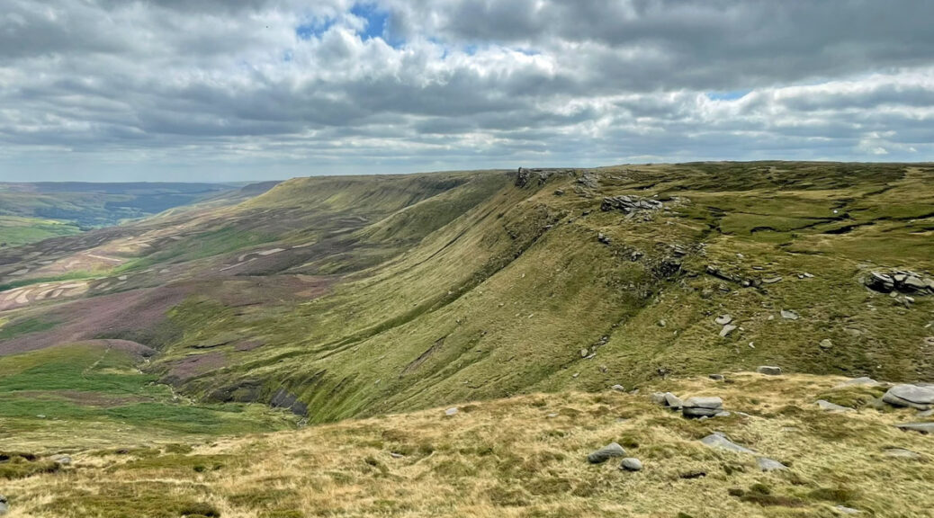
Whichever path you have taken, ultimately you will reach Kinder plateau. From a distance this may look flat but it is riven by deep peat groughs, which require surmounting or much circumvention. Few continuous paths cross the plateau and navigation is quite an undertaking amidst few landmarks, so a bearing is often useful, although difficult to follow because walking in a straight line is impossible. This is not only due to the meandering groughs but compounded by boggy sections that may not actually swallow you entirely, although certainly look like they will. On a wild day this can be a vicious landscape. In his splendid gazetteer, Kinder Log, Trevor Nelson aptly describes the twenty square miles of the plateau as “Very leg weary. After a downpour, the plateau becomes a battlefield and you are the enemy”.

As you flounder across, you become a part of the moor, in sympathy with its own struggle for survival. The plateau may appear indomitable, yet it is fragile. Despite marginal direct human attrition until modern times, northern England was the focus of the Industrial Revolution and atmospheric pollutants drifted high before settling upon the moors, stifling the growth that held the peat together. The resulting denuded landscape fell into a pitiful state, however, since 2011 the National Trust have been carrying out a fifty-year plan to restore the peat habitat, so important in these burgeoning environmentally sensitive times. The bare peat is being planted with sphagnum moss to slow water run-off and spread with heather brash to act as a mulch to encourage plant growth. The results so far have been remarkable.

Upon the moor and surrounding the rim of the plateau are rocks, lots of them, and many exhibit vivid personalities. These heavily weathered formations are one of Kinder’s greatest joys. Most are scattered around the edges, those few on the plateau itself are rarely worthy of names. One exception is the Madwoman’s Stones, a name that tantalisingly beckons from the map. I can assure you that you will not fail to be disappointed by these moderately sculptured rocks but you will go anyway, just like I did. The stones lie towards the eastern side of the plateau and those approaching from that direction are favoured with a relatively straightforward visit, as reaching them from the west requires considerably more effort. However, for those already on the west side, the Kinder Gates are a feature easily seen. These are natural stone posts through which an infant River Kinder trickles, having gathered moisture from the surrounding dampness before ‘plunging’ over Kinder Downfall, usually in a rather subdued manner as rarely is there much flow of water. To create a spectacle, the waterfall does easily freeze in winter and also looks impressive on windy days when it blows back on itself.

To walk the complete circuit of Kinder Edge is highly recommended although with the characteristics of an expedition. It can be split, if you are willing to brave crossing the plateau, with the northern, western and southern sections from Ringing Roger heading around Kinder Downfall, and the northern edge as far as Seal Stones, providing the most stimulating selection of sculptured stones. The shortest crossing of the plateau is known as the ‘seven minute crossing’ and departs from just west of Nether Tor along Dry Clough (if you are lucky!) heading due north. If coming the other way a slightly longer crossing goes from the head of Blackden Brook across to the prominent Hart’s Horn boulders by Upper Tor.

For the circuit, Ringing Roger, Nether Tor and Upper Tor lead to the top of Grindsbrook Clough marked by a large cairn. There are a scattering of stones here including a large solitary boulder overlooking the clough that in modern times is known as ET rock for a striking resemblance to the happy alien! From Crowden Brook a concentration of formations commences with Crowden Tower, the astonishing Woolpacks, which appear like a scene from Easter Island; these are followed by Pym Chair, the Pagoda and Noe Stool (also called the Anvil), the latter being a perch above the source of the River Noe. Circling around the western scarp are the Edale Stones before arriving at Kinder Low and Kinder Downfall. The northern section is officially known as The Edge and yields fantastic shapes such as the Boxing Glove Stones. Beyond, is the thrusting Fairbrook Naze (nose), a fine place to embrace the wildness before following the rugged Seal Edge (originally Seele, so no marine connection) to the Seal Stones.


To complete the circuit, it is still a fair trek with fewer landmarks of distinction beyond Blackden Brook. However, there are of course the aforementioned Madwoman’s Stones and, once back to the southern rim, the Druid’s Stone, another feature named by legend. What is most appealing here are the views across the Vale of Edale to the Great Ridge and, if this walk has not been far enough, the ridge is connected to Kinder by a mighty circuit known as the Edale Skyline (see Great Ridge feature).

The Boxing Glove Stones. Well, crossing Kinder can be a fight sometimes…
Worthy Rating: 78
Aesthetic – 21
Complexity – 18
Views – 14
Route Satisfaction – 15
Special Qualities – 10