The Cobbler – the upstart of the south
Popularity is bestowed on some hills due to their arresting appearance regardless of their altitude; Stac Pollaidh is an audacious example and so is the Cobbler, which scores on an additional front due to its southern Highland location, thus accessible to the masses from the Scottish Central belt.
To describe the mountain as being like a triple-peaked alpine aiguille is perhaps an exaggeration, despite being part of the grandly titled ‘Arrochar Alps’ and, if transported to Skye, The Cobbler would lose quite an edge off its drama. However, there are no worthy comparisons on its home turf and that has assured stardom. The neighbouring hills may be higher but none are as dramatic.
The fanciful name helps too. The mountain is more correctly titled Ben Arthur (Ben Artair in Gaelic) supplanted by this improbable appellation which merely applies to the summit rocks, although is generally employed for the entire hill. Apparently a couple of centuries ago the locals coined the name, although originally they referred to the hill as the ‘Crooked Shoemaker’. It is the central, highest top that is the actual Cobbler, with the other two peaks (north and south) being the ‘last’ that he is bending over and the ‘Cobbler’s Wife’ standing behind him. There are conflicting reports as to which is which, particularly as the whole analogy is such a stretch of the imagination to visualise in the first place!
The map can be zoomed in or out to change the scale
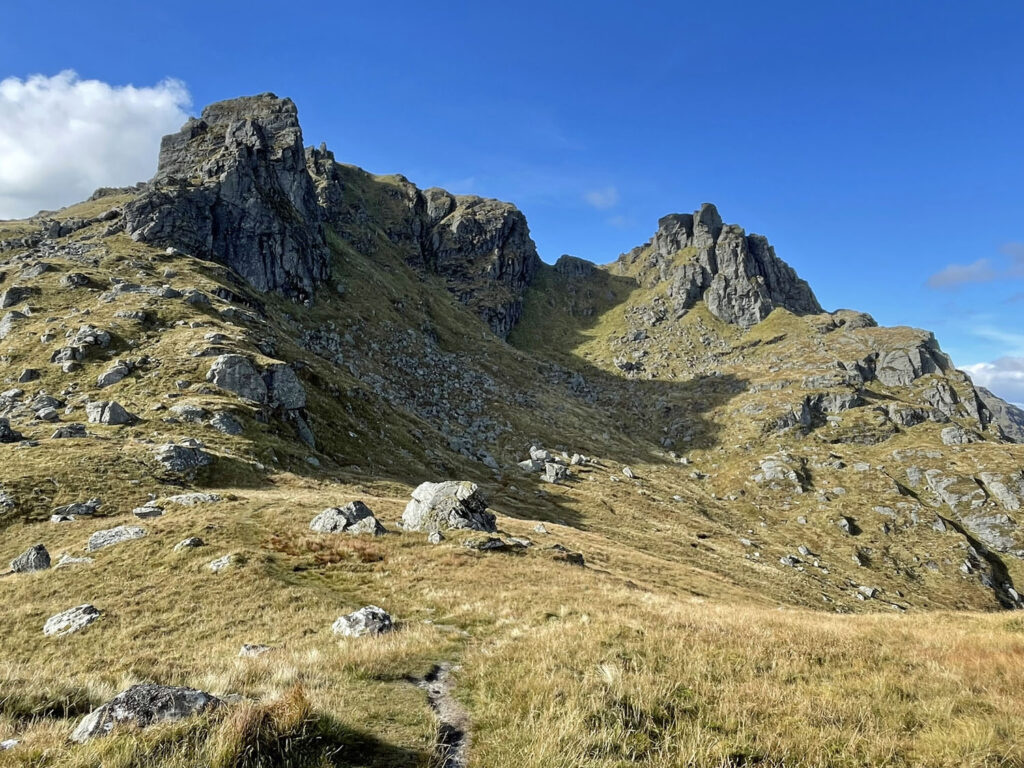
In an area where flamboyantly rocky summits are rare due to the underlying rock type (schist), why has the Cobbler taken this form? The answer is not through glaciation carving out the jagged outline but through an almighty landslip at the end of the Ice Age, roughly 14,000 years ago. The whole of the southern flank of the mountain was affected with the summit ripped apart, resulting in these perilous formations.
The hillside remains unstable to this day, exacerbated during periods of heavy rain. The busy A83 road climbing through Glen Croe beneath the southern slopes is frequently closed, often on a more than yearly basis, the 4,000 vehicles a day having to be rerouted by an additional 25-mile journey. The Old Military Road that runs below the modern road has been reinstated and current plans are to upgrade this further and use it for a period of years while a mile-long protection shelter is built over the modern road.
This southern aspect of The Cobbler is the least attractive, although an ascent route does exist into Coire Croe and is mainly employed by those making a circuit to also include Ben Ime and Beinn Luibhean. There isn’t much of a path on this side of The Cobbler, a testament to its lesser-trodden appeal.
To most people The Cobbler is all about its compelling skyline as seen from Arrochar, thus reducing the perceived complexity of the mountain, whilst boosting its aesthetic appeal. The ‘Worthy Rating’ at the foot of the page reflects this.
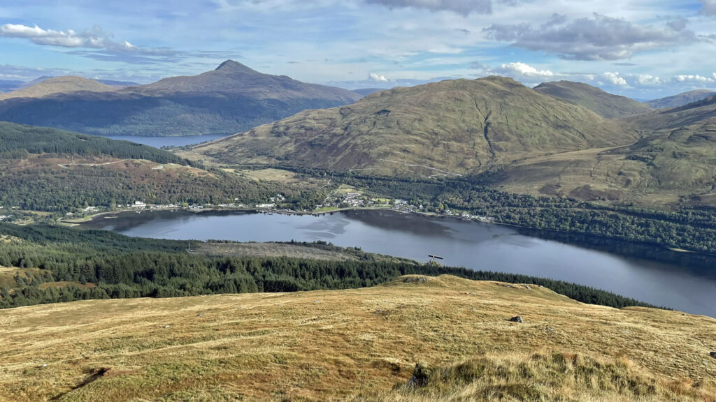
There is very much a standard outing that the majority of walkers undertake, beginning at Succoth car park on the shores of Loch Long. It is important to bear in mind that this is sea level and even though Ben Arthur is a ‘mere’ 2,900 feet in altitude (884m), one climbs every single foot of that height. Nevertheless, for the most part the path is dry and well-surfaced, making for a generally amenable ascent.
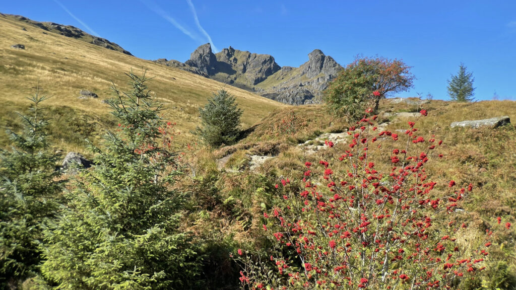
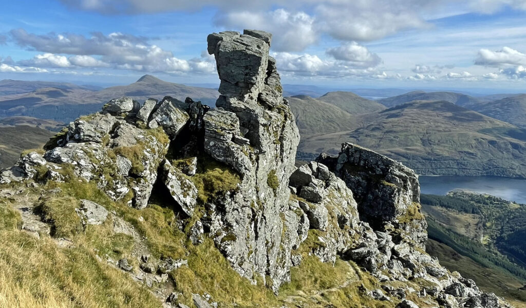
The popular route zig-zags up through the woods, emerging into the open at around 1,000ft, to then follow the Allt a’ Bhallachain (known charmingly as the Buttermilk Burn) at a gentle gradient, with the pugnacious triumvirate at the head of the glen becoming more enticing with every step. Presently, the two huge Narnain Boulders loom beside the path. This side of the mountain was unaffected by the landslip and shaped in traditional glacial fashion, the ice having hollowed out the bowl of Coire a’ Bhalachain above prior to depositing these enormous rocks as it melted. It’s a photogenic spot to linger and a historic one too, because these boulders were a favoured camping place (the impecunious would bivouac) for Clydeside climbers pioneering routes on the Cobbler, the foremost climbing ground in the Southern Highlands. In fact, the first climbing club in Scotland was named ‘The Cobbler Club’ and founded in 1866. Doubtless sport would have been enjoyed grappling with the boulders for practice, and in modern times when ‘Bouldering’ is a climbing activity in its own right, there are currently ten named routes on the Narnain Boulders.
From the boulders, a circuit is the usual order of the day, either ascending directly into the corrie and, after summitting, dropping down the north ridge to the Bealach a’ Mhaim, thence easily back to the boulders. It can be accomplished in either direction although it is perhaps more comfortable to ascend the corrie than descend it, certainly the steeper parts. The north ridge also has a steep section just above the bealach but there is a good pitched path at that point.
Leaving the boulders, the stream is crossed and the lower pitched path obvious as it rises into the heart of the rocky corrie. The middle part is more of a free for all, as the route splits into looser scree alternatives, before a pitched path is regained towards the top. The atmosphere of the corrie is brooding and impressive, although never feels forbidding despite appearances from below. You may hear the echoing calls of climbers on the north peak crags towering above you and are quite likely to meet them when you gain the same top by your rather less serious alternative.
At the foot of the north crag, should you wish to detour, there is a curious and very deep gash known as the Cobbler Cave, an official climb, although one rarely attempted due to the frequent stories of climbers using its depths to relieve themselves!
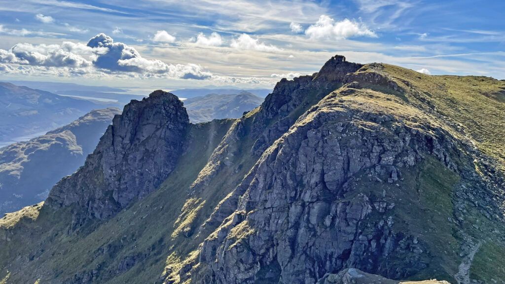
Our path attains the summit ridge at a high col. The north peak with its fearsome fang of rock suspended over a void indicates that the final ascent to this top may be a struggle, but thankfully it is not. A path leads up easily to meet smooth slabs, where it becomes more worrying, although traversing left and circling around the back of the peak provides safe access to the top. If dry, the slabs are actually fine for most people to clamber up without any concern.
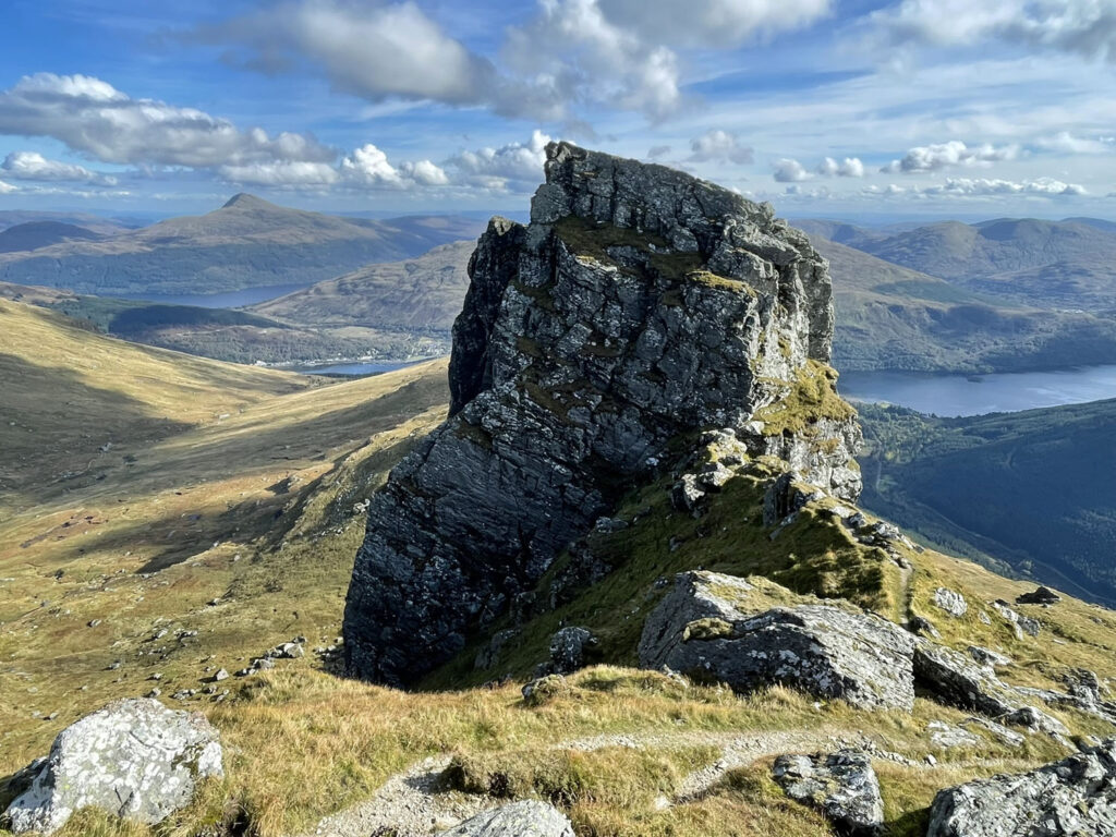
The north peak is the second highest of the three, although is the only actual top that most people attain, access to the tops of the centre and south peaks entails some climbing. Nonetheless, this is a spectacular place to be, perched on the brink of the precipice.
Back to the col, the straightforward ascent is made to level ground adjoining the main central summit. The rocky pinnacle that forms the precise highest point is only reached by ‘threading the eye of the needle’, involving an ungainly movement through a distinctive rock window followed by airy moves above, regarded as a grade 3 scramble. Most people wisely choose discretion as the better part of valour and decline the invitation to be the highest person on the mountain. As a face saver, think of it like the sacred Kanchenjunga, where to touch the physical summit is to defile the mountain.
From here, the standard route returns to the col and drifts below the north peak prior to descending the north ridge. Before doing so, some walkers will make the short diversion to take a closer look at the south peak, the most inaccessible of the three, where virtually no one attempts the final ascent. The peak, when it is climbed, is not generally climbed from the col, but from the south side, a longer grade 3 scramble.
Rather than following the normal route back to the north, there is an alternative that deserves better recognition. Beyond the south peak, the south ridge leads directly back in the direction of Loch Long. It formed the ridgeline on the left all the way on the approach alongside the Buttermilk Burn. The initial prospect of escaping down the side of the south peak looks potentially daunting but provides no difficulties and there are impressive neck-craning prospects of the crags. The angle soon eases and a grassy path with the odd damp section trundles happily along the ridge. The temptation is always to turn around and enjoy observing the three peaks from a slightly different perspective. This route would also make for a fine ascent, the only drawback being the lower section, reaching the ridge from the burn, which looks straightforward from below, although in reality is steeper than it looks and rather boggy. Yes, it is odd to have steep grass and bog at the same time! In descent it is quick and mostly involves tramping down the long grass to provide support. The burn is crossed by the small dam and the outward route regained, feeling slightly less fresh than the last time you were here, but certainly more accomplished after the adventures of the day.
Worthy Rating: 72.5
Aesthetic – 25.5
Complexity – 12
Route satisfaction – 14
Views – 15
Special qualities – 6
One thought on “The Cobbler – the upstart of the south”
Another very worthy mountain that not only punches above it’s height, but punches far too far south for it’s rocky summits and crazy outline